The Economy and Material Culture of the Karak Plateau in the Ottoman Period
Abandoned house at Khirbat Faris
The written accounts of the Karak plateau, and the remainder of southern Jordan in the fifteenth century paint a picture of a region in crisis. In the historical chronicles of the period there are descriptions of incessant bedouin raiding upon both travelers and the settled communities. The Mamluk government no longer had the will or the capacity to control the area, and many villages were depopulated. The area of land under cultivation diminished, and the tax revenues gathered from these formerly prosperous areas dwindled. Assuming that this instability continued into the Ottoman period, then we would expect to find a region almost devoid of occupation. Indeed, this was what apparently greeted the first Europeans to visit the Karak plateau in the early years of the nineteenth century. The intrepid traveler John Lewis Burckhardt (died 1817) reports that beyond the small urban center of Karak itself, there were few permanently settled villages on the plateau. This situation was also encountered further south. It was not until the end of the century that population levels started to increase and many previously deserted villages (Arabic: khirba or khirbat) were reoccupied.
Therefore, there seems to be a clear causal relationship between the instability of the late Mamluk period and the level of depopulation and barrenness witnessed by travelers in the nineteenth century. It can be argued that the situation of the nineteenth century was simply the culmination of centuries of neglect by central government. There are reasons to question this model of events on the Karak plateau from the fifteenth to the nineteenth century, and to understand these it is necessary to consider other sources of information. The accounts written by historians of the late Mamluk and early Ottoman periods were usually by scholars who lived in cities such as Damascus and Cairo. These men would have received news of Jordan through other sources, and probably never visited such regions in person. There is another type of written document from this period that offers a different perspective; it is known as the daftar-i mufassal (an Ottoman tax register). In the aftermath of the conquest of the province of Damascus in 1516 the Ottoman authorities ordered that a census should be taken to determine the tax revenues to be collected from the inhabitants of the cities, towns and villages. Although it seems likely that officials would have made some use of earlier Mamluk tax registers (made before 1516), they still needed to travel to the regions to check the facts for themselves. Similar cadastral surveys were performed at regular intervals in order that the information employed by functionaries of the state remained accurate. Several examples of such documents survive from the sixteenth century, and one published example dating to 1596 contains valuable information about the Karak plateau.
The information in the daftar-i mufassals is subdivided according to administrative regions and districts. By 1596 the whole of Jordan formed part of the liwā’ (equivalent to a sanjaq) of ‛Ajlūn. The liwā’ was split into smaller districts known as nāhiyas. Each nāhiya was given a name, usually that of the major town of the area; Balqā’ was known as the nāhiya Salt and the Karak plateau, the nāhiya Karak. South of the Wādī al-Hasā were the nāhiya Jibāl Karak and the nāhiya Shawbak. The daftar lists the towns, villages, and major bedouin groups within a given nāhiya. Each entry gives the number of taxable households and the value of the agricultural produce, livestock, and other taxable activities of the locality. Typically, the entries for nāhiya Karak contain data on wheat, barley, ‘summer crops’, olive trees, vines, ‘goats and bees’, and a total for the whole. It is not known why goats and bees are listed together as a single category; it may be that this curious title was meant to cover all forms of livestock (archaeological studies indicate that cattle, sheep, goats, and camels were all raised in the area). The town of Karak itself was evidently a more important commercial center, because there are references to a market toll and a treasury. In addition, the entry for nāhiya Karak mentions four water mills (presumably used for milling flour) and a tax levied upon trading with the pilgrimage caravan. This annual event must have brought considerable extra money into the economy of the Karak plateau.
How is the information in the daftar-i mufassal to be interpreted? At one level these lists appear to be a straightforward record of the population and economic resources of a region, but it is important to recognize that the figures recorded in the document represent the revenues the state hoped to collect rather than what was actually produced year by year in each village, town or region. The numbers might also be rounded up for the purposes of convenient calculation. Soon after 1596 the Ottoman state found that it was unable to collect any revenues from the region, and no more cadastral surveys were made in southern Jordan until the second half of the nineteenth century. Therefore, the daftar-i mufassal may be regarded as a ‘snapshot’ of the liwā’ ‛Ajlūn at a specific moment in its history. Allowing for the disparity between the information in the document and the reality on the ground, we can still infer that the Karak plateau was a relatively populous and productive agricultural region in the latter part of the sixteenth century. In previous centuries the plateau had been a major producer of cereal crops and, to a lesser extent, fruit, olives, and livestock. The daftar suggests that this productivity continued into the Ottoman period. It is likely that the instability of the seventeenth and eighteenth centuries did cause some decline in the overall population, but this was probably not as extreme as has often been suggested. The land did not suddenly become less fertile because the Ottoman authorities no longer controlled it; rather, the agricultural surplus was exploited by others, notably the powerful families of the plateau. Charles Doughty (d.1923), who visited Karak in the 1880s before the re-imposition of direct Ottoman rule, noted that wheat was so cheap and plentiful in the town that it was ‘almost as sand’.

Interior of house at Khirbat Faris
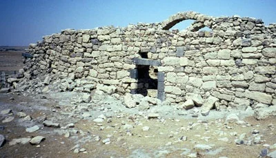
One of the most visible remnants of the Ottoman period on the Karak plateau is the surviving domestic architecture. It is often difficult to date these buildings with any precision, because of the absence of inscriptions or documentary evidence, but it is probable that the majority dates from the eighteenth through to the early part of the twentieth century. The houses make use of the plentiful local building stone, and vary in size and complexity. Usually, the stone is roughly shaped and bonded with mortar. The most ambitious of these domestic buildings are rectangular in plan with a single entrance, and a roof supported on between one and four transverse arches. The arches are, in fact, the core of the building and were constructed first, and with solid foundations. The outside wall was then built around with the addition of a single doorway, and occasionally one or two windows. This method of construction means that it is often the arches that endure longest as abandoned buildings start to collapse. This design allowed for a central vaulted space with niches to either side. These niches were often filled in to create bins for the storage of wheat and barley.
Such buildings were intended for practical purposes, and the ornamentation is usually kept to a minimum. Sometimes, people would make use of pieces carved stone that probably came from earlier buildings. An example of this can be seen in the façade of an abandoned house in the village of Mhay. The absence of windows in these buildings would have made them dark and poorly ventilated, but this becomes more explicable if one considers how they were meant to function. Their primary roles were in the storage of crops, and the safeguarding of livestock. For the majority of the year the owners of the houses would have lived in tents pitched around the house; a practice that is well adapted to the hot temperatures on the plateau from April to November. It was only in the coldest months of the winter that the interior of the house would be used for human occupation. Although constructed using relatively simple technologies, these houses were well designed to perform the tasks required of them. The disadvantage of the rough stone and mortar construction is that it requires considerable annual maintenance.

Facade of traditional house in Mhay

Nineteenth-century house built into the walls of the old town of Karak
In the town of Karak it is still possible to see examples of traditional architecture dating to the nineteenth and early twentieth centuries. Some make use of the existing architecture, such as a house near to Burj al-Banawī that is actually built into the remains of the old town wall dating to the Ayyubid and Mamluk periods. The lower part of the house (entered by a doorway in the remains of the fortified wall) is now abandoned, but the upper part (with its entrance on the interior of the town wall) is still occupied. Other types of architecture exist from this period in Karak.

Shrine dedicated to Noah in cemetery outside the walls of the old town of Karak
A shrine dedicated to the Biblical Noah (Arabic: Nabī Nūh) can be found in a cemetery on the outskirts of the town. It is not known when this site was first associated with Noah (this is not the only location in the Middle East said to contain his tomb), but the simple domed masonry structure probably dates to the nineteenth century. The continued survival of many Ottoman buildings remains in doubt, however. In the twentieth century the introduction of reinforced concrete has resulted in many people in the villages and towns abandoning the traditional stone houses. Although many of the older houses have been lost, there is now an active effort in Jordan to preserve this important part of the architectural heritage of the country.